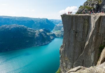
Norway’s iconic cliff formation Preikestolen (Pulpit Rock) has been grabbing headlines this summer.
Overlooking the Lysefjord, the spectacular location offers awe-inspiring views and is one of Norway’s most visited attractions. So much so, that CNN placed the site atop their list of 50 natural wonders (the Geirangerfjord and Nærøyfjord also make the list), and last month newspaper Stavanger Aftenblad reported on the upcoming nine-day closure of the attraction to film scenes for the Tom Cruise spy movie “Mission: Impossible 6” in late September.
But, the recent question being posed by those within the scientific community is whether or not Preikestolen is at risk of collapsing and creating a flood in the fjord below. Of particular concern since the 1930s is a half-meter wide gap in the rock, which is several meters deep. Despite remaining unchanged for over two decades, measurements taken in May suggest that the space has widened by 2-3 millimeters.
In an effort to increase monitoring efforts—previously geologists installed bolts on both sides of the crack to test expansion—the Geological Survey of Norway (Norges geologiske undersøkelse, NGU) will be applying modern methods. Scans and high-resolution aerial photography will be taken from all angles to better document changes within the rock. In addition, 3D models of the surface will be generated by the Norwegian University of Science and Technology (NTNU) to assess stability. NTNU researcher Marina Böhme says,“If we find that there is danger of collapse, it will be appropriate to install permanent measuring equipment.”
Preikestolen is among 32 other mountains in Rogaland receiving similar attention from geologists. Last year NGU conducted a study via helicopter to identify and map all mountains that may pose an avalanche risk. Mapped locations are then filtered through a classification system with the highest priority sites receiving the strongest mitigation measures and attention.